Unearthing the history of our watchman’s shanty!

 Click on each image for a closer look!
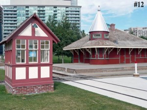
One of the valued and restored artifacts at the Toronto Railway Heritage Centre, and the smallest of the four structures in the railway village, is the watchmen’s shanty, which is now mounted on a permanent foundation just a few yards northwest of Don Station. The shanty, also known as a gatehouse, was used to provide a protective shelter for the guards that were employed by the railways to stand watch at the numerous grade crossings that used to exist in Toronto. When trains approached, these watchmen would lower the gates, or at less busy intersections, block traffic while holding up a sign, preventing vehicles and pedestrians from crossing the tracks until the train had passed.
The TRHC shanty was built around 1914 following a standard pattern used by the Canadian Pacific Railway for structures of this type. Many of these buildings were mounted at the top of 5-meter towers so that the watchman could see a train coming in the distance and lower the gates in time. In busy industrial areas, where trains operated at a much lower speed, the gatehouses were mounted close to the ground. Another key factor determining the height of the gatehouse was whether there were single or multiple tracks to guard. At a two or more track crossing the view of multiple tracks from the shanty could be obscured by a train or cars spotted on the track adjacent to the shanty. The solution was to elevate the shanty a sufficient height to give a clear view over multiple tracks.
More information about these structures can be found on the plaque in Roundhouse Park. The contents and location of this plaque (and all TRHC plaques) can be reviewed by clicking here.
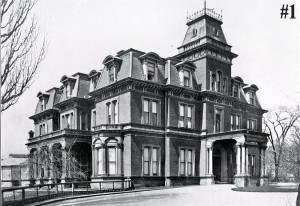
Before explaining how the shanty came to be built, a little background on Toronto history is in order. In 1912, the CPR purchased a plot of land bounded by King, Simcoe, Wellington and John streets for a new freight facility that would specialize in handling less-than-carload freight and the railway’s rapidly expanding express business. For several decades the site had been the location of Government House, the residence of the lieutenant-governor of Ontario. On the next block to the south were the provincial parliament buildings that dated back to the 1832 when the province was known as Upper Canada.
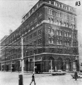
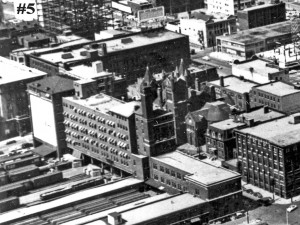
After the parliament buildings moved to Queen’s Park in 1893, the southern lot was bought by the Grand Trunk Railway early in the 20th century and a freight shed occupying the entire block was erected after the buildings were demolished. This made Government House a much less attractive location and the vice-regal residence was relocated to Chorley Park in Rosedale in 1912. The CPR then bought the property and erected a freight yard similar to the GTR facility, with a large express building running along Simcoe Street.
C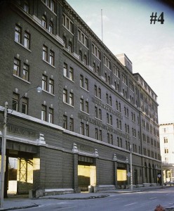
 PR then had to deal with the issue of how to bring the tracks up to their new facility since the mainline railway corridor was at a considerably lower elevation. The solution was a ramp carved into the embankment on the south side of Front Street. This ramp began at Bathurst Street and emerged at street level just west of the Spadina Avenue bridge. At this point the tracks angled northeast towards the Simcoe Street freight yards. Gatehouses were then erected at Front, Peter and John streets to guard those grade crossings.
By the 1970’s, the railways were abandoning their express and less-than-carload freight business. Canadian National closed their facility south of Wellington Street in 1967. The CPR facility hung on for another decade until it too was demolished to make way for Metro Hall and Roy Thomson Hall.
In 1977, the John Street gatehouse was donated to the Toronto Historical Board who, in turn, gave it to the Canadian Railroad Historical Association, when it was moved to the Loblaw’s Building at the foot of Bathurst Street. In May 1978 the structure became the parking lot shanty for the CRHA’s Toronto Railway Museum at Pier 4 on the waterfront. When that museum closed in 1986, the gate house was moved to the John Street Roundhouse and completely restored in time for the opening of the Toronto Railway Heritage Centre in 2010.
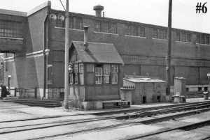
For many years I had sought a photograph of the gatehouse at its John Street location. It appeared that it was one of those humble railway structures that photographers never bothered with. On Boxing Day, 2011, Toronto author and raconteur Mike Filey emailed two photographs to me that he had found in his collection. Mike has written dozens of books on various aspects of Toronto history, some with a focus on transportation, and produces a weekly column for the Toronto Sun newspaper. One of his photographs was clearly identified as the CPR gatehouse at Spadina. The other was unlabelled although it certainly was similar to the TRHC structure. I wasn’t sure because of the brick structure passing over the street so I sent the image to Raymond Kennedy, who confirmed that it was the John Street gatehouse. I then consulted a 1950’s fire insurance map of the area and there was the overhead structure and the exact number of tracks. So, we’re pleased to present a photograph of the gatehouse at its original location.
It’s interesting to note that from April until August 2011, the shanty was hidden away inside the Roundhouse Theatre tent, in the middle of the lobby. Rather than move the structure, it was decided to leave it in place, where it was used to store items that were on sale at the refreshment counter.
#1 – Government House at King and Simcoe streets, demolished in 1912 to make way
for the CPR freight facilities.
#2 – This government navigation map from 1964 shows the track arrangement for the
CPR Simcoe Street facilities. There were a total of 16 tracks between John and
Simcoe.
#3 – The CPR Express building at Simcoe and King streets.
#4 – Another view of the CPR Express building looking north towards King Street.
Toronto Archives
#5 – This aerial view shows the track arrangement and west side of the CPR Express
buildings.
Toronto Archives
#6 – The photograph was taken just north of Wellington Street looking south on the
west side of John. Notice the old locomotive bell on the east side of the
shanty. How long could you leave something like that out in the open today?
The brick building was a CPR freight shed, which connected through the
overhead passageway to another freight shed east of John. Way over on the left
you can just make out the Hydro station, which is the only part of this image
that is still there. – From the Mike Filey collection
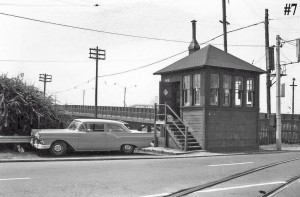
#7 – The other image shows the gatehouse for the same route at Front & Spadina.
That’s the Spadina bridge in back of the gatehouse. At this point, the track
finished its long climb up from the railway corridor that began at Bathurst
Street and then angled off northeast towards John Street. TRHA webmaster Russ
Milland has identified the watchman’s car as a 1957 Ford Tudor sedan. – From the Mike Filey collection
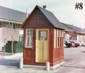
#8 – The shanty when it was used as a parking booth at the CRHA’s railway museum.
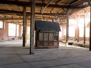
#9 – The gatehouse when it was stored inside to roundhouse, just prior to being moved to Oakville for restoration. – Norm Betts photograph
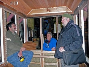
#10 – The gatehouse under restoration at Tom Murison’s Oakville facility in December
2008. Tom restored all four buildings in the THC’s railway village. From left
to right are Tom, roundhouse restoration architect Don Loucks and TRHA
president Orin Krivel. – Derek Boles photograph
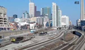
#11 – The remains of the CPR ramp can be seen underneath the two blue drums just
left of centre in this 2010 view taken from the Bathurst Street bridge. – Derek Boles photograph
#12 – The gatehouse in its permanent location at the Toronto Railway Heritage Centre.
Posting by Derek Boles, TRHA Historian

