Mike Filey Shares Historic Toronto Railway Images: Part 1 of 3
Many TRHA members who are also interested in the history of Toronto are probably familiar with local historian Mike Filey. Mike has written dozens of books on Toronto history, including a couple devoted exclusively to the city’s streetcars. He writes a weekly column for the Toronto Sunday Sun called The Way We Were, which often deals with railway subjects, including the John Street Roundhouse. Years before the Roundhouse became the Toronto Railway Museum, Mike was a public advocate for that development. Every couple of years, his columns are collected and published in book form as Toronto Sketches. Volume 11 of that series was recently published by Dundurn Press and features a colour postcard of Union Station on the front cover (see image #1 below). Mike and I often correspond about railway topics and recently he sent me a number of photographs of railway locations around the city.
The first grouping of photographs were all taken around Canadian National’s Riverdale Station. The station had been built as Queen Street East by the Grand Trunk Railway in 1896, the same year as Canadian Pacific’s Don Station. Like Don, the station was a convenience for passengers living in Toronto’s rapidly expanding east end so they wouldn’t have to make the trek all the way downtown to Union Station to catch a train. The station was renamed Riverdale, as the neighbourhood had become known, in 1907.
The Queen Street East level crossing was considered one of the most dangerous in the city, and for good reason. On November 17, 1904, a collision between a Toronto Railway Company wooden streetcar and a Grand Trunk freight train at this location killed three and injured seventeen. The gates had been lowered by the attendant to allow passage of the fast freight from Montreal when Toronto Railway Company car no. 642 crashed through the barriers at 6:35 PM with about 20 people on board. The train smashed into the front of the streetcar, dragging it 200 feet farther down the line.
#2 – The only photograph in the collection with precise information identifies it has having been taken on December 28, 1925. This view is looking north (actually slightly northeast) towards Riverdale station on the west side of the tracks. The road crossing over the tracks is Queen Street East. The four crossing gates and the overhead streetcar wire are plainly visible.
#3 – Shows a closer view of the station itself taken from north of Queen Street. A track crew is at work on the right, while a gentleman strolls towards his automobile parked beside the station. The smoke overhead is from the chimneys of the Dunlop Tire & Rubber Goods Company located east of the tracks. In the mid-1920’s, work began on the Waterfront Grade Separation that would elevate the railway tracks above city streets. The track elevation and the new underpass, or subway as they were then known, at this location required that Riverdale station be relocated a hundred feet or so to the northwest.
#4 – Appears to have been taken at the same time as the previous photograph. The asphalt platform has been removed to facilitate the station’s relocation. The platform evidently helped support the brick structure as wooden braces have been installed to hold the station up. An oil lamp hangs above the station operator’s bay window and seems a rather inadequate way to communicate with train crews compared with Don Station’s more conspicuous semaphore arms.
#5 – Much more wooden bracing has been added to protect the building while workmen dig out around the foundation prior to the station’s relocation. A temporary wooden bridge has been added to provide access to the tracks. Around the time these images were made in late 1926, four runaway CN freight cars crashed into a crowded TTC streetcar at this crossing, fortunately without the loss of life caused by the 1904 collision.
#6 – The station is shown in its new location, away from the new elevated right of way. An identical photograph in the City Archives indicates that it was made on October 25, 1927, a little less than two years after the first image in the series. The street on the left is DeGrassi, popularized in the recent series of teenage television dramas. The Dunlop Rubber complex can be seen on the right.
#7 – The final image in this series is dated 1930. A concrete retaining wall runs alongside the DeGrassi Street sidewalk while three workmen are grooming the earthen embankment supporting the tracks. A tunnel has been built for passenger access to the new elevated train platforms. The entrance can be seen between the two telegraph poles on the left. There is some evidence that a baggage elevator was installed and the small structure at track level may be the upper part of the elevator shaft.
The relocation and improvements to Riverdale Station were evidently unsuccessful since Canadian National closed the facility in 1932 as a Depression austerity measure. The building was then variously used as a gospel hall, a carpet factory, a taxi dispatch office, a grape vendor, and a heating firm, and survived until 1974, when it was demolished. An image of the station has been incorporated into the logo of the Riverdale Historical Society.
The area around the tracks north of Queen Street has been redeveloped as Jimmie Simpson Park, named after Toronto’s first socialist mayor, who served in 1935-36. Ironically, given the history of the location, Simpson was killed in 1938 when his automobile collided with a streetcar. In 2012, Heritage Toronto and the Riverdale Historical Society unveiled an interpretive plaque on the site of the station.
Click here to read part 2 of this series of postings
Posting by Derek Boles; Photos provided by Mike Filey.
Click on each image for a closer look!
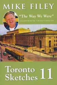 |
| 1: – “Toronto Sketches” buy Mike Filey . |
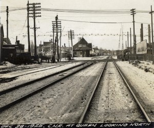 |
| #2: Riverdale Station from the South – December 28th, 1925 . |
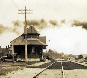 |
| #3: Riverdale Station from the North . |
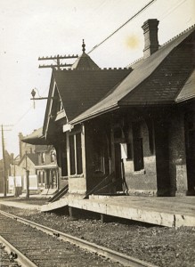 |
| #4: Riverdale Station , |
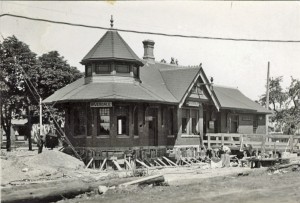 |
| #5: Riverdale Station just prior to relocation in late 1926 , |
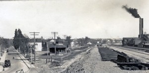 |
| #6: Degrassi Street & Riverdale Station – Oct 25th, 1927 , |
 |
| #7: Riverdale Station, DeGrassi St. and the Elevated Mainline – 1930 , |

